
“Egeria’s account is very precise, detailed, clear and direct to the point that it
does not make room to any personal interpretation. She portrays the territory in
a photographic manner, describing the form and position of the mountains,
the form and dimensions of the valley, the precise distances and travel times
from one point to the other.”
Flavio Barbiero
We read at: EGERIA AT HAR KARKOM (altriocchi.com) – web site of Flavio Barbiero
Summary: - The paper shows that Har Karkom was known as the biblical Mount Sinai by Christian pilgrims of the first four centuries C.E. Evidence is provided by a manuscript found in 1884 in the Tuscan town of Arezzo, with the diary kept by a Christian pilgrim, named Egeria, who at the end of the IV century made a trip to the mountain of Moses. Immediately the scholars decided that the account was referred to St Katherine, but unfortunately the description, very accurate and detailed, does not fit at all the reality of that mountain, perhaps apart a single match at the end of the visit. The described distances, travel times and description of the environment are unsuitable to the area of Santa Catherina in a macroscopic way. Besides, the pilgrim reports the existence of monks’ communities and agricultural sites both on the mountain and in the surrounding valley, including dwellings and churches which, according to the archaeological evidence, did not exist there at that time.
In all evidence the account is referring to a different location. Through an accurate survey at Har Karkom, however, it becomes plausible that the narrative refers to a journey made on that precise area. If we strictly follow the indications of the manuscript, starting from the very point where the pilgrim looked out from a gorge over the God’s valley, we are then taken along an itinerary completely matching, down to the smallest detail, the information provided by the diary, at the point that it could be regarded as the best guide ever to a biblical tour of Har Karkom.
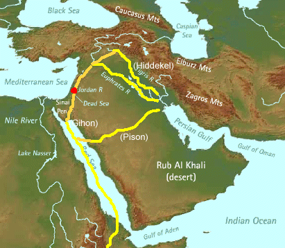
Sinai, a Nabatean mountain
An interesting outcome of the archeological discoveries at Har Karkom is that this mountain was known as the biblical Sinai since the beginning of the Christian era. As a matter of fact, 30% of its 1200 archaeological sites belong to the roman-byzantine epoch and in all probability they were due to communities of monks, who thrived there until the beginning of the 7th century, when they were swept away by the Islamic invasion.
St. Paul, in his letter to the Galatians, says that soon after his conversion in Damascus he went for “three years to Arabia”, that is the kingdom of the Nabateans, adding after a few rows that “Sinai is a mountain of Arabia” (4, 25), within which borders there is Har Karkom.
The existence of monks, more precisely ebionites[1], in that area is testified by Epiphanius, who in his book “Panarion” (30, 18, 1 & 29, 7 7-8), written on 375, says that they were spread over most of the provinces of the Nabataean Arabia. His words were confirmed a few years later by a Roman pilgrim, Egeria (381-384), who in his diary described communities of monks in Transjordan, as well as around and on top of the God’s mountain.
In the following pages we will show that this mountain was not the St. Katherine, but Har Karkom, that fits entirely the pilgrim’s description.
The Codex Aretinus
Egeria’s diary was discovered on 1884 in Arezzo, Tuscany, and it’s written on a parchment called Codex Aretinus 405, produced between 1087 and 1105 in the monastery of Monte Cassino. [2]
The initial, the final and four intermediate pages of the manuscript are missing. No other copies of the diary have been found so far, but precious information about the content of the missing parts is contained in a letter, written around 680 by a monk named Valerius to his brothers of Bierzo’s monastery, in Galicia, Spain, in which he makes a list of the mountains climbed by the pilgrim and of the biblical sites that she visited.
Egeria’s pilgrimage to the Holy Land took place between 381 and 384 and the visit to the mountain of God is supposed to have been made at the end of 383.
Mackey’s comment: I would not necessarily accept as accurate any of these AD dates.
Unanimously the scholars agreed that the mountain visited by the Roman pilgrim had to be identified with the St Katherine massif, in the southern part of the Sinai Peninsula, which the Christian tradition blessed as the biblical Sinai since the beginning of the sixth century (the very first mention of it as a possible biblical Sinai is made by Procopius, historian at the court of emperor Justinian).
A survey made on 1899 by M. J. Lagrange, trying to identify on the St Katherine an itinerary somehow fitting the narrative of the manuscript, failed to demonstrate a close match with it, to the point that 90 years later another scholar, Franca Mian, made a second attempt, proposing a few alternatives, with the same disappointing result.
Mount Sinai in Egeria’s description
Egeria’s account is very precise, detailed, clear and direct to the point that it does not make room to any personal interpretation. She portrays the territory in a photographic manner, describing the form and position of the mountains, the form and dimensions of the valley, the precise distances and travel times from one point to the other. She describes what she sees near the path she walks along, relating everything to the biblical text: tombs, churches, caves, ancient encampments, dwellings, altars and so on. All real elements that should be easily verified by a survey on the concerned area.
She reports her own activities with precision and coherence, her movements, the precise time of every activity, and her encounters with monks who lived upon the mountain and in the surrounding valley.
These information allow us to draw a precise outline of Egeria’s visit to the holy mountain.
Dimensions of the God’s valley and distances
In Egeria’s account the valley’s dimensions and the distances between key points are reported with precision:
- four miles from the entrance of the valley to the mountain (§1,2 of the manuscript),
- sixteen thousand footsteps the length of the valley and four thousand footsteps its width (§2,1);
- three miles from the top of Mount Horeb to the site of the burning bush (§ 4,5);
- thirty five miles from Faran to the mountain of God (§ 6,1).
These are important information and therefore it is essential to understand what they really mean. The Romans, when marching their armies through Europe, used the unit of long distance mille passuum (literally "a thousand paces"), corresponding to about 1,480 meters (1,620 yards), because each pace or stride was two steps. If this was the unit of length used by Egeria, then the distances reported in her account were respectively of 6, 24, 4.5 and 52 km.
Egeria, however, is keen to point out that those measures were told to her by the local guides, ignorant monks who almost certainly were not familiar with the Roman army practices. For them distances had to be expressed in simple footsteps, of about 70 cm each, and therefore those values go down to 3, 12, 2.2 and 26 km. Besides, those distances were measured along the paths and therefore they were a little bit longer than the distances as the crows fly. Let’s say a 10 % longer.
In the first case the dimensions of the God’s valley were of 22 km by 5, hugely out of scale in the St Katherine scenario. In the second and more probable case, these dimensions are reduced to 11 by 2.5 km, still at least three times longer than the real ones.
Surprisingly the distance from the God’s mountain to Feiran (and only this) is correct if it was expressed in Roman miles (while is half of its real value if expressed in normal footsteps). A part this lonely match, in both cases the dimensions of the God’s valley, as reported by Egeria’s diary, are macroscopically wrong in the St. Katherine’s scenario, as can be seen in the following map.
Maps and pictures show that there is no match between Egeria’s account and the geography of the St. Katherine, with the only exception of the distance from Feiran to that mountain (which in any case could not have been covered in one day only, as we understand from the manuscript).
A manipulated account
A large part of Egeria’s account is dedicated to encounters with several monks who lived in that area, and to describe churches, agricultural sites, both upon the mountain near its top and in the surrounding valley, archaeological remnants, attributed to the exodus’ Jews, and so on.
Nothing of this kind existed in the St. Katherine area at Egeria’s time. We can therefore state with certainty that her account is related to a different mountain.
There are, however, two data that look correct in the St. Katherine scenario: the declared distance from Faran to the God’s mountain is the same as that from Feiran to the Gebel Musa (if we suppose that it was expressed in Roman miles), and the fact that Egeria, according to the manuscript, went on on her trip following backward the legs of the Jews’ exodus, undoubtedly starting from Feiran, because two days later she reached the Red Sea shores and walked along the beach up to Suez and then to Egypt.
Clearly there is some problem with this narrative. Through a thorough analysis of the manuscript we can easily find it out. Let’s jump directly to the conclusions. The codex found in Arezzo is not a full transcription of the original Egeria’s diary, but only a “collage” of excerpts, quoting the journeys outside Jerusalem made by the pilgrim during the three years of her sojourn in the holy city, assembled in a different order from the original.
From Valerius’ letter we know that the very first journey of Egeria was made to Egypt, where she followed “all the legs of the ancient peregrination of Israel…”(Cap.1). Only later, “burning for the desire to see the holy mountain of God” (cap.2), Egeria programmed a dedicated journey to mount Sinai.
In the manuscript the order of the two journeys has been inverted and they have been put in sequence in such a way as to make the Faran of Egeria coincide with the oasis of Feiran. In this point the copyist inserted the distance of 35 miles, which couldn’t be known to Egeria in this form, because that distance was expressed in Roman miles only in the VI century, when emperor Justinian established a garrison in Feiran and built a fortified monastery at the foot of Gebel Musa.
Evidence of this manipulation is shown at page 37 of the Codex Aretinus, where a footnote, written by the copyist, tries to fix some contradiction, yielded on the text by the operation of connecting in the wrong sequence two different journeys.
….
Thus, the only data in the manuscript, supporting the identification of Egeria’s holy mountain with the St Katherine, is devoid of any value.
EGERIA’S ITINERARY AT HAR KARKOM
Egeria’s diary is too precise, coherent and detailed to be a fantastic tale; it certainly describes a real journey in a real place. Let’s see then how it fits the area of Har Karkom.
If we set all the information provided by the manuscript in the Har Karkom’s scenario, we are forced to follow an itinerary that matches completely, down the smallest detail, the data provided by Egeria.
1st day - From Beer Ada (Faran) to the site HK 183
The starting and return point of the itinerary is Beer Ada, a site at the confluence of wadi Karkom with wadi Faran, whit important archaeological remains of the roman-byzantine period. It’s an obligated choice, because Egeria left and returned back to a place named Faran.
….
Read the full, fascinating article.


Comments