Bab edh-Dhra complex not biblical Pentapolis

by
Damien F. Mackey
“These cities, five in all, have been suggested as possible candidates
for Sodom and Gomorrah, the five cities of the plain. However, the narrative of
Numbers 31, Moses’ attack on the Midianite cities, fits the details better,
particularly when one views the nature of the destruction at these cities. It
was not the type of geological destruction that the narrative of Sodom and
Gomorrah would suggest, but far closer to that which would be wrought by human
agency”.
Dr John Osgood
Introduction
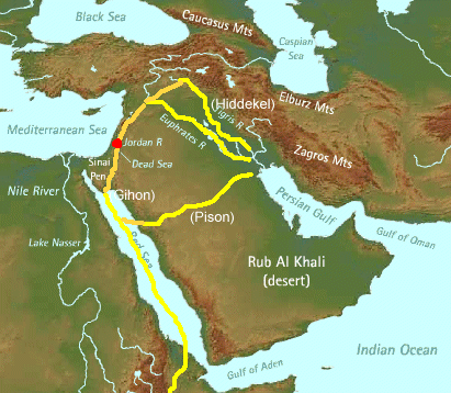
The most popularly suggested locations for
the biblical sin city of Sodom and its satellites are either the Early Bronze Age
cities situated in the environs of Bab edh-Dhra (map taken from Dr. Osgood’s “The Times of the Judges -The
Archaeology: (a) Exodus to Conquest”, Fig. 12) http://creation.com/the-times-of-the-judges-mdash-the-archaeology-exodus-to-conquest

or, for Sodom, the more northerly Middle Bronze
Age site of Tell [Tall] el-Hammam (http://www.dailymail.co.uk/sciencetech/article-3270999/Has-Biblical-city-Sodom-Monstrous-site-Jordan-matches-descriptions-area-destroyed-God.html)

Bab edh-Dhra and Numeira
Bryant Wood appears to consider the identification
of these two sites as, respectively, Sodom and Gomorrah, to be a “conclusion”
that is “inescapable” (“The Discovery of the Sin Cities of Sodom and Gomorrah”)
(http://www.biblearchaeology.org/post/2008/04/The-Discovery-of-the-Sin-Cities-of-Sodom-and-Gomorrah.aspx),
Looking for
the Sites
Sodom and Gomorrah were two of five cities referred to in Scripture as
the Cities of the Plain. From references to the "plain of the Jordan"
(Gn 13:10), "the Valley of Siddim (the Salt Sea)" (Gn 14:3) and
Abraham looking down to see the Cities of the Plain from the area of Hebron (Gn
19:28), it is clear that the cities were located in the vicinity of the Dead
Sea. Since the mountains come close to the shore on both the east and west, the
cities must have been located either north or south of the Dead Sea. Various
commentators over the centuries have suggested locations both north and south
(Mulder 1992: 101 102). The reference to "bitumen pits" in Genesis
14:10, however, tips the scale in favor of a southern location (Howard 1984).
Bitumen (a natural petroleum product similar to asphalt) was commonly found in
the shallow southern basin of the Dead Sea in antiquity. (Bilkadi 1984; 1994;
Clapp 1936a: 901–902; 1936b: 341–342).
One popular theory, repeated yet today, is that the Cities of the Plain
were located in the plain south of the Dead Sea and later covered by the waters
of the southern basin, never to be seen again. The level of the Dead Sea has
receded substantially in recent years, causing the southern basin to dry up.
(2) Extensive exploration and activity in the area has produced no evidence to
indicate that there were ancient sites there (Rast 1987a: 193).
It wasn't until 1973 that solid archaeological evidence for locating the
Cities of the Plain was found. At that time an archaeological survey of the
area southeast of the Dead Sea was conducted by Walter Rast and Thomas Schaub
in conjunction with their work at Bab edh-Dhra, an Early Bronze (ca. 3300–2000
BC) site on the east side of the Lisan peninsula.(3) Rast and Schaub discovered
four additional sites south of Bab edh-Dhra, which they suggested might be
related to the Cities of the Plain of the Old Testament (Rast and Schaub 1974).
Subsequent excavations at Numeira, 13 km (8 mi) south of Bab edh-Dhra, have
verified its close affinity with Bab edh-Dhra. ….
….
Even though the locations of three of the Cities of the Plain remain
elusive, evidence is strong that the two most important, Sodom and Gomorrah,
have been found.
Identifying the Sites
Bab edh-Dhra and Numeira are the only known inhabited towns in the region of the Dead Sea between ca. 3300 and 900 BC. Moreover, Bab edh-Dhra is the largest site from the pre-Hellenistic period in the area (Rast 1987b: 46). The conclusion that these sites are associated with the Cities of the Plain is inescapable (Rast 1987a: 190–94; 1992: 561).
….
The site to the north of Numeira, Bab edh-Dhra, would then be Sodom. Since Bab edh-Dhra is the largest ancient ruin in the region it stands to reason that it should be identified as Sodom, the most famous of the Cities of the Plain. It was occupied throughout the Early Bronze Age for a period of over 1,000 years.
[End of quote]
According to
the above, “… it is clear that the cities were located in the vicinity of the
Dead Sea”. But I think that we can be far more precise than that, thanks to the
editorial work of holy Moses. There was no Dead (or Salt) Sea, in fact, when Pentapolis
was flourishing in the fertile Valley of Siddim. The Dead Sea was an effect of
the catastrophe that destroyed those cities and turned the erstwhile Valley of
Siddim into a Sea of death.
I explained
this as follows in my article:
Editor Moses
Added Vital Geographical Clues for the Genesis Flood and Sodom
….
So Moses, whilst carefully preserving
the original patriarchal histories, had also up-dated these, as editors do. For
example, he provided new names in cases where older ones had since been
replaced.
And, in so doing, Moses has allowed
for us to know exactly where Sodom was located.
Genesis 14 apparently was in
particular need of an update. Hence we are advised by Moses:
Bela (that is, Zoar)
(vv. 2, 8);
Valley of Siddim (that is, the Dead Sea)
(v. 3);
En Mishpat (that is, Kadesh)
(v. 7);
Hobah (that is, north of
Damascus) (v. 15);
Valley of Shaveh (that is, the King’s
Valley) (v. 17).
And what has all this to do with
Sodom?
Well it is to the fertile valley
region of the Valley of Siddim (v. 3), where Sodom was located, that Lot had
chosen to dwell (Genesis 13:10-11): “ Lot looked around
and saw that the whole plain of the Jordan toward Zoar was well watered, like
the garden of the Lord, like the
land of Egypt. (This was before the Lord
destroyed Sodom and Gomorrah.) So Lot chose for himself the whole plain of the
Jordan and set out toward the east”. According to (http://www.keyway.ca/htm2002/20020708.htm):
“Lot chose to live in the Valley of Siddim because it was then "well
watered everywhere like the garden of The Lord" …”. By the time of the
Exodus, though, we find, the Valley of Siddim, shockingly, had virtually ceased
to be. Moses tells the Israelites that it was now “the Salt Sea” (the Dead
Sea), a most desolate region - sometimes described as the ‘entrance to Hell’.
[End of quote]
This fact alone probably renders worthless
such favoured locations as the above-mentioned sites for Sodom, and would incline
me to favour, instead, a search along the following lines, at the bottom of the
Dead Sea (http://www.israelnationalnews.com/News/News.aspx/141132):
However, some archaeological evidence has emerged
that indicates that the site could be on the east bank of the Dead Sea, with
two sites in Jordan - Bab edh-Dhra, and Numeira, both considered viable
candidates. The Jordanian-Russian search will center on Bab edh-Dhra, which
also has several Christian monuments.
According to Madani, further
evidence that the cities remains are located on the Jordanian side of the Dead
Sea came after recent NASA photographs of the area indicated that the bottom of
the sea is littered with debris and objects not found in other bodies of water.
According to the Jordanian, Israel recently sent a submarine down into the Dead
Sea in an attempt to explore the bottom of the sea, but discovered that the
objects in the NASA photos were on the Jordanian side of the sea. Jordan
prevented the Israelis from searching over the border, and now Jordan is
seeking to discover what it believes are the remains of the cities by itself.
[End of quote]
Tell el-Hammam
Another hopeful, Steven Collins, believes that the site of Tell el-Hammam
where he is involved matches “every Sodom criterion” (“Possible site of
ancient Sodom yields more finds”): http://popular-archaeology.com/issue/june-2013/article/possible-site-of-ancient-sodom-yields-more-finds)
Now
having completed the tenth season of excavations, an archaeological team headed
by Steven Collins of Trinity Southwest University, New Mexico, has unearthed a
goldmine of ancient monumental structures and artifacts that are revealing a
massive Bronze Age city-state that dominated the region of Jordan’s southern
Jordan Valley, even during a time when many other great cities of the “Holy
Land” region were either abandoned or in serious decline.
Known as
Tall el-Hammam, Collins has been leading excavations at the imposing mound, or
tel, since 2005.
"Very,
very little was known about the Bronze Age in the Middle Ghor (southern Jordan
Valley) before we began our excavations in 2005," says Collins. "Even
most of the archaeological maps of the area were blank, or mostly so. What
we’ve got on our hands is a major city-state that was, for all practical
purposes, unknown to scholars before we started our Project."
Indeed,
according to Collins, when comparing it with the remains of other nearby
ancient cities, along with its prime location and dates of occupation, it
emerges today as the best candidate for the lost city of Sodom—the infamous
city that, based on the Biblical account, was destroyed by God in a fiery
cataclysm because of its iniquity.
"Tall
el-Hammam seemed to match every Sodom criterion demanded by the text," he
says. "Theorizing, on the basis of the Sodom texts, that Sodom
was the largest of the Kikkar (the Jordan 'Disk', or 'well-watered plain' in
the biblical text) cities east of the Jordan, I concluded that if one wanted to
find Sodom, then one should look for the largest city on the eastern Kikkar
that existed during the Middle Bronze Age, the time of Abraham and Lot. When we
explored the area, the choice of Tall el-Hammam as the site of Sodom was
virtually a no-brainer since it was at least five to ten times larger than all
the other Bronze Age sites in the entire region, even beyond the Kikkar of the
Jordan."
[End of
quote]
This choice for Sodom, Tell el-Hammam,
is perhaps an even worse fit than is Bab edh-Dhra for the geographical guideline
as provided by Moses (Genesis 14:3), and it is archaeologically even more too
late for Abram (Abraham) according to my:
Better archaeological model for Abraham
in which is completely rejected the
current opinion that the patriarch Abraham belonged to the Middle Bronze Age.

Dr. John Osgood, the only one to
establish a realistic and workable archaeology for Abraham - and indeed for
much that follows his time (Exodus, Conquest, Judges) - has also managed to
make complete sense of the Bab edh-Dhra complex. So I believe.
They are cities of
Midian
In his “Times of the Judges …”,
Osgood has well explained:
Region 3—The EB IV—MB I
People of Trans Jordan: A Cultural Smorgasbord
Trans Jordan becomes a
snare for archaeological interpretation since I believe any attempt to
interpret the archaeology of EB IV—MB I in Trans Jordan is doomed to failure in
ultimate analysis unless one takes cognisance of the biblical narrative of the
Exodus and Conquest.
Historical Framework
Numbers 21 fills in some
fascinating history about Trans Jordan. The following facts emerge, from the
north downwards (see Figure 10):
1.
The Amorite king, Og, ruled in Bashan in the far north.
2.
It appears that the original kingdom of Sihon, the Amorite, was just
north of the Wadi Zerqa, known in the Bible as the River Jabbok (Numbers 21:24)
3.
It appears originally that the former king of Moab had ruled the area
south of the River right down to the Wadi el Hasa (Wadi Zared)
4.
Prior to Israel conquest of this area, Sihon had conquered the area
between the River Jabbok and the Arnon River from the former king of Moab. It
appears, importantly for our discussion, that he did not totally drive out the
Moabites from this area but they served him (Numbers 21:29,
where captivity is mentioned).
5.
In the days of Israel’s conquest, Moab under Balak, king of Moab, was
the territory between the Wadi el Hasa and Wadi Mujib (Arnon).

Figure 10. Map showing the territories of Bashan, Sihon
and Moab. (See also Fig. 11).
The conquest by Israel of
Trans Jordan extended from the Wadi Mujib right up north to include all the
area of Bashan—in other words, all the area of Sihon and all the area of Og,
king of Bashan. It explicitly did not include the main area of Moab, south of
the Wadi Mujib (see Figure 10 again).
These facts will give us
the following guide archaeologically (see Figure 11):
1.
The northern kingdom of Bashan should show evidence of Amorite civilization,
here equated with EB III, which was ended by the MB I peoples, here called
Israel.
2.
The area of Gilead north of the Jabbok River but south of Bashan should
have exactly the same pattern as that of Bashan EB III superseded by MB I
civilization, where Israel settled.
3.
The area between the Wadi Mijib (Arnon) and the Wadi Jabbok will show
evidence of three phases, the lower phases representing Moabite culture, here
defined as EB IV, a second layer representing Sihon’s civilization holding
Moabites captive, here it will continue to be EB IV and then a third culture
representing the Israelite conquerors (MB I).
4.
In Moab south of Wadi Mujib we will meet with an EB IV culture which has
arisen from a previous EB III culture, and which will continue on in that vein
without explicit conquest by the MB I people.

Figure 11. Table comparing the parallel development of
Moabite and Amorite cultures, and Israelite conquest west of the Jordon River
This pattern (see Figure 11
again) is, in fact, exactly what we find from the archaeological reports
presently at hand.
EB IV in Trans Jordan is,
in fact, defined most clearly in the area of ancient Moab. It will, however,
include a portion which was occupied by the group known as the Midianites
mentioned in Number chapter 31. The area where these Midianites lived can
logically be identified if one bears in mind that the Midianites were
associated geographically with the Moabites, and close to Israel’s encampment
north of Moab in such a way that the social intercourse with the Midianite
women at Beth–Peor could occur. And if one bears in mind that when Moses lived
in the northern Sinai–Negev region during his forty years of exile from Egypt,
he came in contact with this Midianite group and married one of their women.
Then clearly the only geographical spot where these Midianites could have lived
is in the western portion of Moab, east of the Dead Sea, and perhaps at its
southern end (see Figure 12). It is just there that the cities of Bab Ed–Dhra,
Numeira, etc. have been excavated, all of which show signs of destruction at
the end of EB I and subsequent poor repopulation by the EB IV people (here
defined as Moabites).
….
These cities, five in all,
have been suggested as possible candidates for Sodom and Gomorrah, the five
cities of the plain. However, the narrative of Numbers 31, Moses’ attack on the
Midianite cities, fits the details better, particularly when one views the
nature of the destruction at these cities. It was not the type of geological
destruction that the narrative of Sodom and Gomorrah would suggest, but far
closer to that which would be wrought by human agency.
The area between the Jabbok
and the Wadi Mujib is the most interesting of these areas, especially as a
number of sites have been excavated in this area providing consistent results,
particularly at the sites of Iktanu and Tel Iskander.
Prag,8 while discussing Tel Iktanu, points to two
phases, both particularly emphasising red coloured ceramics, essentially of an
EB IV phase with similarities to the Moabite area EB IV, and also states that
these red slipped or burnished pottery of Iktanu phase 1 and southern type are
not to be found in the areas north of the Wadi Zerqa (Jabbok).
She saw the Jabbok as a
border area, so that what in essence is occurring in this part of Trans Jordan
is two phases of what might be called EB IV followed then by MB I, often built
on different sites. Now this corresponds exceedingly well with the phases
suggested for this area (see Figure 11 again), which was conquered from the
former king of Moab by Sihon and then reconquered from Sihon by Israel.
Down in the south, however,
the red burnished wares continue on through all phases:
“The essential point of
interest for all these southern sites is that red slipped and burnished wares
continued right through the pottery of early and late phases, though there does
seem to be an increase in plain and non–red slip wares towards the end of the
period at the expense of the red wares.” 8
However, north of the
Jabbok or the Wadi Zerqa, we meet the situation where Middle Bronze I sites are
often built straight on sites that previously had to have Early Bronze III
habitation, the Early Bronze IV of the south now being absent.
“They indicate that in the
region north of the Zerqa River in Trans Jordan, significant proportion of
EB–MB sites (approximately half) were founded on the same position as a
previous EB III or EB II settlement.”8
EB–MB in this discussion is
the same as MB I. It is Kathleen Kenyon’s terminology.
The sites in the north
consistently show the evidence of destruction at the end of EB III wherever
excavations have occurred, and a supplanting by the MB I people, a picture that
is thoroughly consistent with the biblical narrative of the– Exodus and Conquest.
….


Comments